Click to load the interactive map
Forward positions convert proximity into sustained operational reach
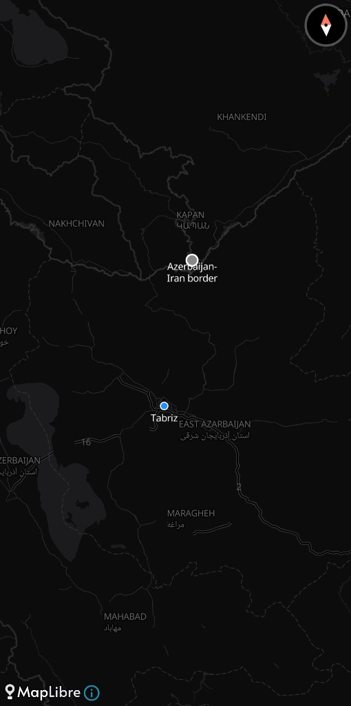
The distance from southern Azerbaijan to Tabriz is about 60 miles. From there, according to multiple sources, Israeli units watched northern Iran and acted.
The units were not symbolic. Several dozen troops—including special operations forces, an elite heliborne rescue unit and Mossad personnel—operated across several locations in southern Azerbaijan, close enough to observe and close enough to act. Special commando units were also deployed to run intelligence-gathering missions and drone operations, creating a perch from which to see into northern Iran. That proximity turns geography into leverage. It also turns the host country into part of the war.
A dispersed network embeds the war across borders rather than extending it
Azerbaijan is not alone. The same network extended across multiple countries, including Iraq, the United Arab Emirates, and Somaliland. Together, the deployments placed Israeli forces along Iran’s southern, western, and northern periphery, stretching operational reach by hundreds of miles. That reach mattered less for a single strike than for repetition: forward positions helped sustain repeated waves of strikes deep inside Iran. The war did not move outward. It was already there.
What made that possible was not just hardware but permission—formal or otherwise. The network gave Israel’s military unprecedented reach and exposed how Iran’s neighbors played a role, some with permission, some likely without. That distinction is the difference between alliance and exposure. It is also the difference between a base and a liability.
Infrastructure built before conflict becomes the condition for it
The Azerbaijan operation had been prepared earlier. In mid-January, as Iran crushed wide-scale protests with mass killings, Israel prepared a covert mission along the Azerbaijan-Iran border. The plan was to embed sensors and listening devices—a preliminary operation laying the groundwork—under cover of opening strikes. When US President Donald Trump called off those strikes, citing Iran’s agreement to halt the killings, the infrastructure remained the objective. Israel proceeded on its own, using stealth jets and special forces to install the devices because its leadership believed negotiations with Iran were doomed. The network was built before the war that would use it.
Once in place, those sites changed what could be sustained. An intelligence node near Iran’s northern border became another means to track military movements and potentially warn of missile launches. A runway in Somaliland provided a point for Israeli aircraft to stop on long-range flights to Iran. In Iraq, two secret facilities offered logistics support and search-and-rescue capacity. In the UAE, an Iron Dome battery and its operators were quietly deployed. Each site solved a different constraint—distance, endurance, survivability. Together they removed them.
Official denials do not alter the strategic geometry they imply
Host governments have not absorbed that implication publicly. Azerbaijan’s embassy in Washington said, “We firmly reject unfounded claims regarding the alleged use of Azerbaijan’s territory for operations against third countries.” Iraq’s military said there were no “unauthorized bases or forces”. The UAE denied that its leadership hosted Israeli officials during the war, despite reports that Prime Minister Benjamin Netanyahu and security chiefs visited. The denials do not change the geometry. They underline it.
That geometry sits inside a region already under strain. The South Caucasus has been a cauldron of volatility since 2020, with Armenia suffering repeated blows from Azerbaijan and large-scale escalations including the 2020 war and the 2023 takeover of Nagorno-Karabakh. Azerbaijan spends more—$2.238 billion versus Armenia’s $634 million—and imports far more—8.2 times Armenia’s arms volume. Israel’s relationship with Baku has grown stronger, alongside rising arms exports and oil imports. The same territory that anchors a regional arms race now hosts part of a wider one.
Markets price scale while exposure accumulates through access
Markets have registered the conflict, but selectively. Israel’s sovereign risk has moved—credit spreads rose about 15% between February 16 and March 16—yet less than during earlier strikes, when they jumped more than 27% in June 2025. Across the region, spreads reacted more severely to the Twelve-Day War than to current operations. Pricing models appear to weight oil reserves and production when estimating credit deterioration. That logic privileges scale over exposure.
But the network does not scale with reserves. It scales with access. A covert site 60 miles from Tabriz creates operational reach that a balance sheet cannot offset. It also creates a dependency that cannot be disclosed. Countries hosting or tolerating those sites—whether they admit it or not—are no longer peripheral to the conflict. They are its infrastructure.
The cost of that position is not yet in their spreads. It sits instead in the fact that Israeli forces were already positioned along Iran’s entire periphery and that those positions enabled repeated strikes across the country. The exposure does not lie in what those states say they allowed. It lies in what their territory has already made possible.